Highway 5 Twinning Project

The Ministry of Highways continues to work on plans for safety and capacity improvements to Highway 5 between Saskatoon and Highway 2. The twinning project is nearing completion of the detailed design period.
1. Background
This information provides the design details for the twinning of the 10 km section of Highway 5 east of Saskatoon.
It also highlights a summary of how previous engagement impacted the design.

Highlights of feedback received throughout the stakeholder consultation for the project, which began in 2019, and how your feedback was considered in design:
| What was heard | What was done |
| Concerns regarding Sunset Estates and RM firehall access. | Reviewed multiple options for Sunset Estates Access, Drews Road alignment, and the service road. Selected design includes realigning Drews Road to be across from Rock Ridge Road and extending existing service road to Rock Ridge Road with a 40 m setback and dust free surface. Reviewed options for realigning east end of service road to intersect Highway 316 further south. Cost, turning for fire hall vehicles, availability of alternate access to the west, and property impacts were all considered during the review, and it was determined to keep the east end of the service road in the existing location. |
| Low traffic volumes on proposed Drews Road service road. | Discussion with the utility tower owner determined that the site is accessed fewer than 10 times a year and there was concern the service road may conflict with the SaskPower line. Outcome was to not install a service road to the utility parcel at the time of this project. |
| Request for more turning lanes. | A westbound acceleration lane will be added at the Highway 5 and Highway 316 junction for vehicles turning left from Highway 316 onto Highway 5. |
Typical Cross Section Without Service Road
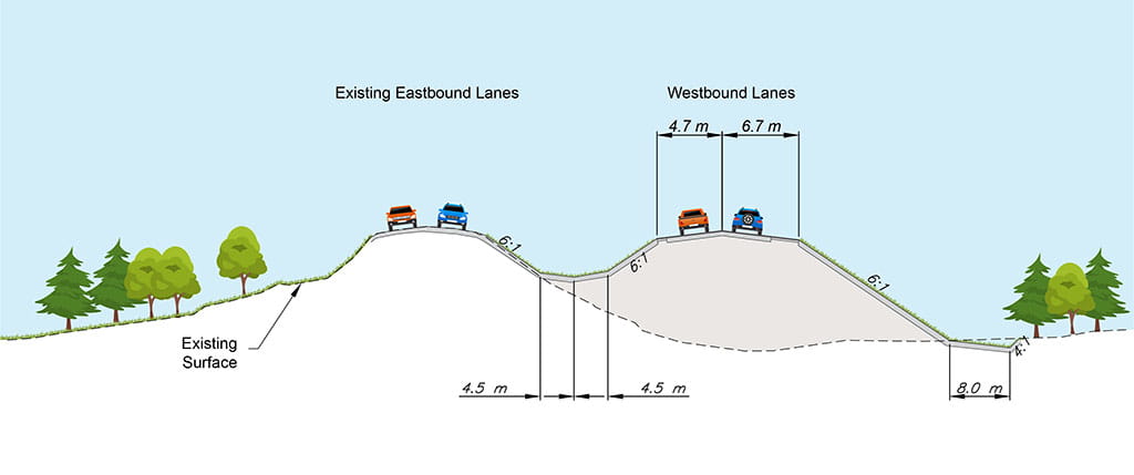
This is an example of a typical cross section of the new highway where there are no adjacent service roads. Each driving lane will be 3.7 m wide with the inner shoulder being 1.0 m wide and the outer shoulder being 3.0 m wide. This is similar to other twinned highways in the province.
Typical Cross Section With Service Road
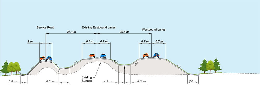
This is an example of a typical cross section of the new highway where there is an adjacent service road. This example also shows the vertical adjustment of the existing highway lanes to improve the sightlines west of Freeborn Road. The width of the median between the eastbound and westbound highway lanes is 32 m. This is measured from the inner edge of the eastbound driving lane (solid yellow line) to the inner edge of the westbound driving lane. This would be similar widths to other twinned highways in Saskatchewan.
2. Intersections and Service Roads
Intersection of Highway 5 & Old 27 Road
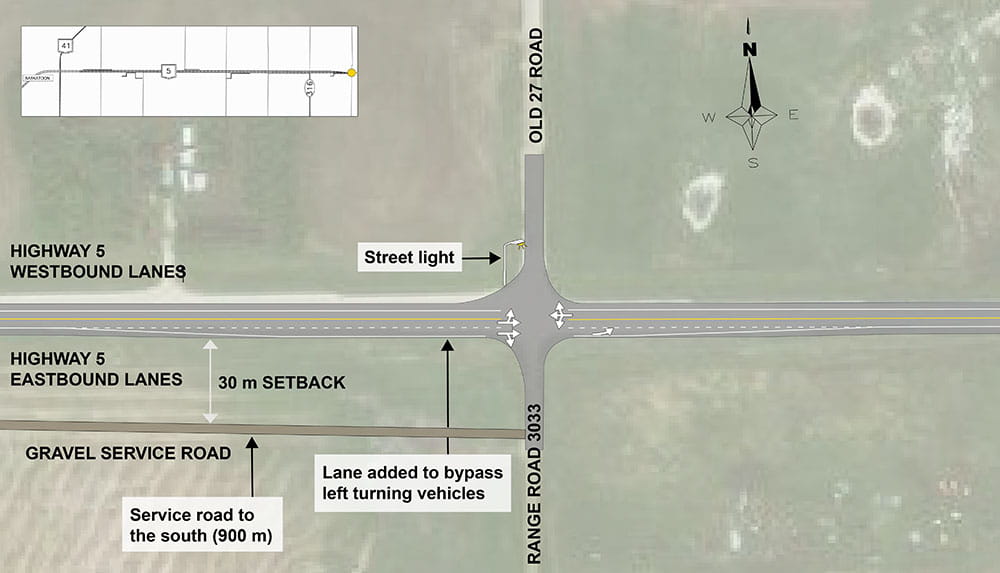
The design for the intersection of Highway 5 and Old 27 Road includes:
- An added eastbound lane at the intersection to bypass left turning vehicles.
- A streetlight on the north intersection approach.
- A 900 m long gravel service road in the southwest quadrant of the intersection.
- The service road will be set back 30 m from the edge of the outer highway lane.
Intersection of Highway 5 & Highway 316
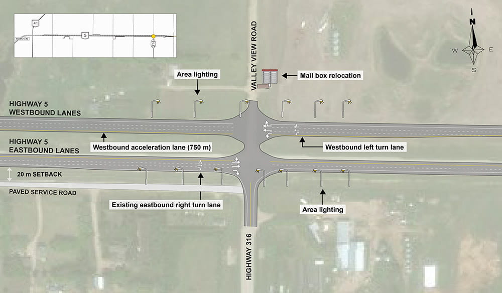
The design for the junction of Highway 5 and Highway 316 includes:
- A westbound left turn lane.
- The existing eastbound right turn lane will stay in place.
- A 750 m long westbound acceleration lane for vehicles going north and turning left towards Saskatoon.
- Area lighting.
- Relocating the mailbox to the north.
In designing the Highway 5 and Highway 316 junction, a review of the east end of the service road intersecting Highway 316 south of the highway was also completed.
Options were considered to realign the service road to the south in order to provide more separation from Highway 5.
These options presented concerns regarding fire hall trucks and water trucks navigating turns, as well as impacts to adjacent properties.
The outcome of the review was to leave the service road at its existing location which has a 20 m setback from the edge of the outer highway lane. The service road will be resurfaced as part of the highway twinning project.
Intersection of Highway 5 & Drews Road
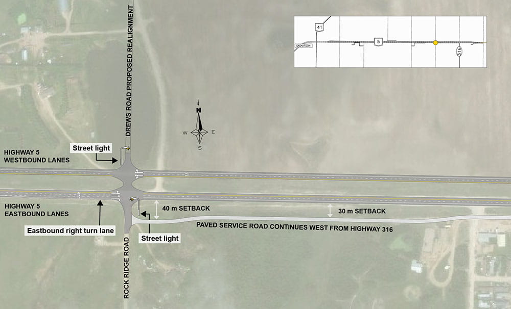
The design for the intersection of Highway 5 and Drews Road includes:
- An eastbound right turn lane.
- Realignment of Drews Road on the north side of the highway to be straight across from Rock Ridge Road on the south.
- Streetlights on the north and south approaches of the intersection.
The design of the west end of the service road providing access to Sunset Estates went through multiple design iterations in consultation with the Rural Municipalities and adjacent landowners.
The design includes the extension of the existing service road west to Rock Ridge Road/Drews Road and the removal of the existing service road access on Highway 5.
The intersection with the service road and Rock Ridge Road will be 40 m south of Highway 5 to provide room for vehicle queuing and turning movements.
The service road will have a paved surface.
Tower Hill Road Service Road
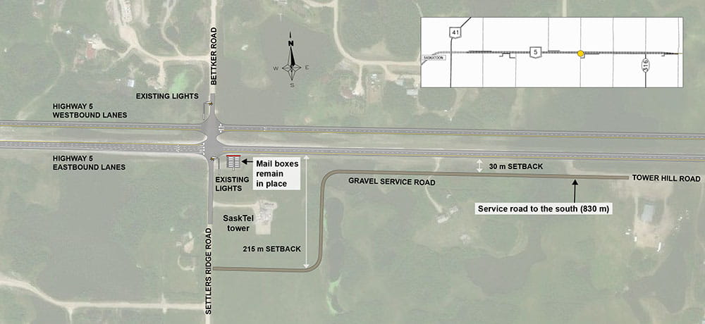
The design of the Tower Hill Service Road has the following features:
- The service road will run from Tower Hill Road to Settlers Ridge Road, curving around the south side of the SaskTel tower parcel. The existing Tower Hill Road access to Highway 5 will be closed.
- The service road will be 830 m long with a 30 m setback from the outer highway lane.
- The service road will intersect Settlers Ridge Road 215 m south of Highway 5.
- The mailboxes in the southeast quadrant of the Highway 5 intersection will remain at their current location.
Intersection of Highway 5 & Bettker Road
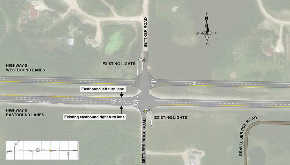
The design for the intersection of Highway 5 and Bettker Road includes:
- An eastbound left turn lane.
- The existing eastbound right turn lane will be kept in place.
- The existing streetlights on the north and south approaches will remain unchanged.
Intersection of Highway 5 & Kilmeny Road
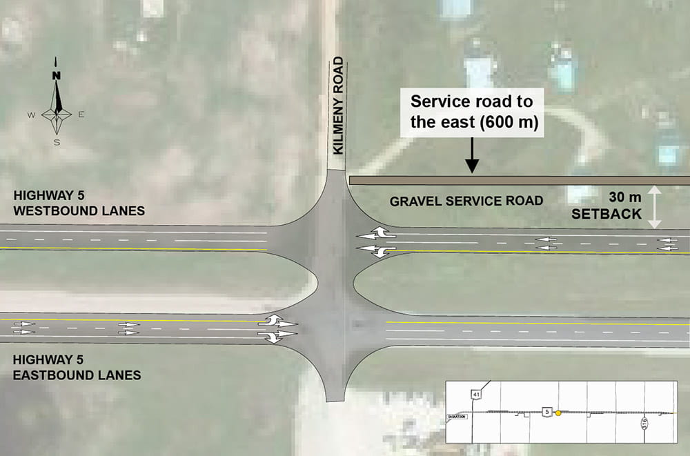
The design for the intersection of Highway 5 and Kilmeny Road includes the addition of a 600 m long gravel service road in the northeast quadrant of the intersection.
The service road will be set back 30 m from the edge of the outer highway lane.
Intersection of Highway 5 & Freeborn Road
Service Road
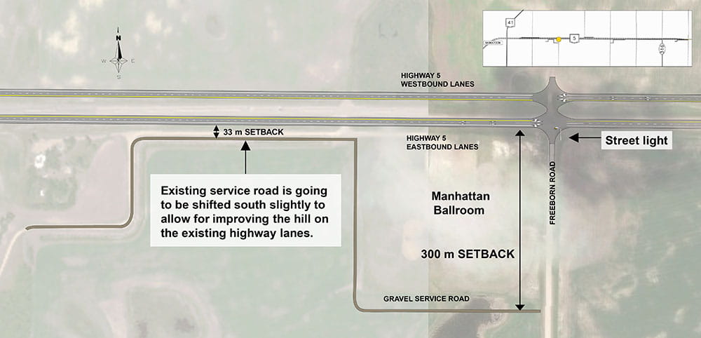
The design for the intersection of Highway 5 and Freeborn Road includes the addition of a streetlight on the south intersection approach.
- The existing service road in the southwest quadrant of the intersection will be realigned along the south side of the Manhattan Ballroom to intersect with Freeborn Road 300 m south of Highway 5 and the existing service road approach onto Highway 5 will be closed.
- The existing service road which runs parallel to the highway will be moved slightly south to allow room for improvements to the highway sight distances on the hill.
- This results in a service road setback of 33 m from the edge of the outer highway lane.
Intersection of Highway 5 & Llewellyn Road
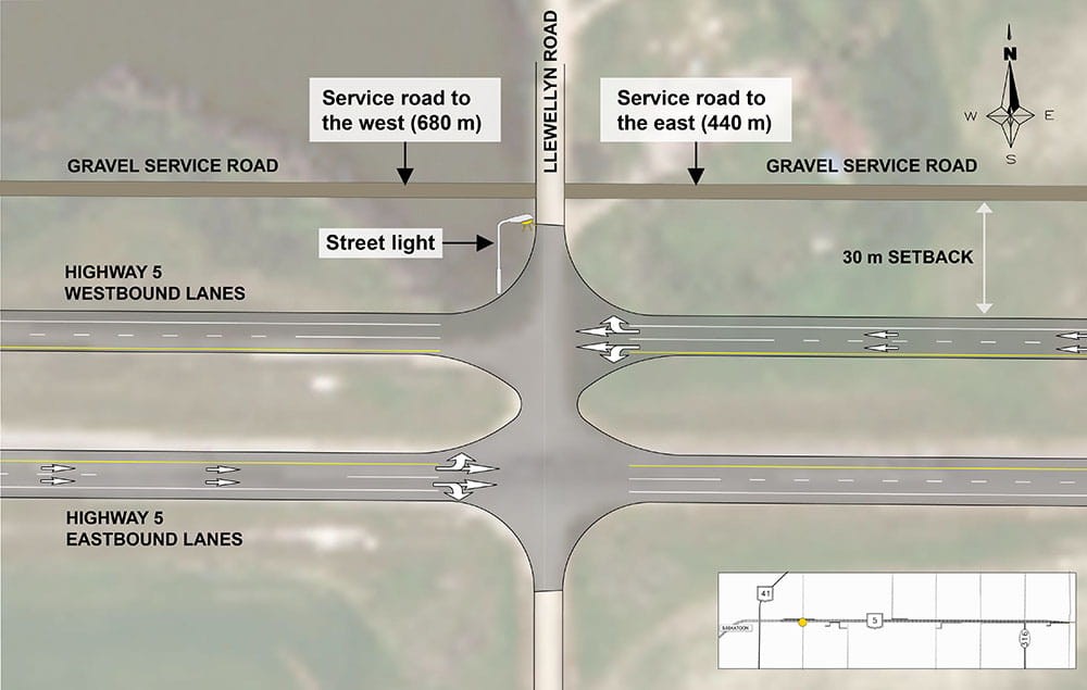
The design for the intersection of Highway 5 and Llewellyn Road includes:
- A streetlight on the north intersection approach.
- A 440 m long gravel service road in the northeast quadrant of the intersection.
- A 680 m long gravel service road in the northwest quadrant of the intersection.
- Both service roads will be set back 30 m from the edge of the outer highway lane.
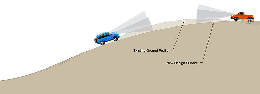
Sightline Improvements on Hill Between Llewellyn Road and Freeborn Road
West of Freeborn Road, there is a hill along the existing highway lanes. In order to improve the sightlines for vehicles driving over the hill, the crest of the hill will be cut down a bit and the valley following the hill crest will be filled in a bit.
Highway Twinning Transition
The transition from twinned highway to undivided highway occurs between Old 27 Road and Highway 316.

3. Next Steps
Preliminary work began in 2019 with design work getting underway in the summer of 2020. Since then, a series of stakeholder meetings and landowner meetings have been held as well as public information sessions. The most recent was held in March 2021. People were asked to review information and provide feedback during a two-week period in January 2023.
While the timeline for construction may change, this represents the latest timeline estimate:
| August 2019 | Public Information Session #1 |
| Summer 2020 to Fall 2022 | Design |
| February 2021 | Stakeholder Meetings – Round 1 |
| November 2020 to Summer 2021 | Landowner discussions regarding access |
| March 2021 | Public Information Session #2 |
| November 2022 | Stakeholder Group Meetings – Round 2 |
| Summer 2021 to Winter 2022-23 | Landowner discussions regarding land purchase |
| January 2023 | Public Information Session #3 |
| 2024 to 2026 | Construction (subject to change) |
4. Share your Feedback on Highway 5 Twinning
Thank you for your feedback!
The survey is now closed.
For more information, please contact us.
