Government of Saskatchewan ministries, Crown corporations and organizations are implementing contingency plans to minimize the impacts of postal service disruption.

Les ministères, sociétés d’État et organismes du gouvernement de la Saskatchewan mettent en œuvre des plans d’urgence (en anglais) visant à réduire les répercussions de l’interruption du service des postes.

Google Translate Disclaimer

A number of pages on the Government of Saskatchewan's website have been professionally translated in French. These translations are identified by a yellow box in the right or left rail that resembles the link below. The home page for French-language content on this site can be found at:

Renseignements en Français

Where an official translation is not available, Google™ Translate can be used. Google™ Translate is a free online language translation service that can translate text and web pages into different languages. Translations are made available to increase access to Government of Saskatchewan content for populations whose first language is not English.

Software-based translations do not approach the fluency of a native speaker or possess the skill of a professional translator. The translation should not be considered exact, and may include incorrect or offensive language. The Government of Saskatchewan does not warrant the accuracy, reliability or timeliness of any information translated by this system. Some files or items cannot be translated, including graphs, photos and other file formats such as portable document formats (PDFs).

Any person or entities that rely on information obtained from the system does so at his or her own risk. Government of Saskatchewan is not responsible for any damage or issues that may possibly result from using translated website content. If you have any questions about Google™ Translate, please visit: Google™ Translate FAQs.

Holding Pond Site Selection and Design

Livestock operators need to contain runoff from livestock facilities, silage pits, or manure piles to prevent surface water pollution. Control works consisting of diversion ditches/dikes and holding ponds may be needed to contain the runoff. Include holding ponds as part of the outdoor corral design, which incorporates proper pen slopes to provide good drainage and pen drying. Construct holding ponds in impervious soils or use man-made materials or imported clay as a liner to provide groundwater protection.

The site selection process for the facility and the holding pond is a step-by-step process. The geotechnical nature of the site and regulatory requirements will influence the required commitment from the developer.

All sites require pre-screening and an initial soils evaluation. For some sites this work will identify the need for a detailed site investigation.

Top

1. Pre-screening

Prior to a site visit or site work, review available well records within a 1.5 km radius of the site to provide information about the geology of the area.

Well records will provide data on:

  • well depths;
  • depths to water-bearing formations;
  • well water levels; and
  • types of soils beneath the surface.

Topographical maps and air photos provide information about surface features in the area and the proximity of surface water bodies and watercourses.

Geologic maps provide information about subsurface conditions.

If pre-screening determines that the site may be environmentally suitable, proceed to an initial soils evaluation of the site.

Top

2. Initial soils evaluation

Active feedlots

Several research studies show there is minimal risk to groundwater from an active feedlot. The compaction by cattle on the soil, combined with the manure, seals the soil surface and prevents infiltration to groundwater. During corral cleaning, take care to ensure the solid organic layer at the base of the manure pack remains intact.

Runoff collected from the feedlot surface has the potential to migrate if not properly stored. Construct holding ponds in clay soils to ensure runoff is captured securely. If the on-site materials cannot achieve this, it may be necessary to use imported clay, synthetic liners or other proven technologies.

Collect soil samples

  • Collect soil samples from the area of the holding pond.
  • Dig test holes around the perimeter of the proposed pond and collect representative samples for analysis.
  • The test holes should extend a minimum of three metres below the final holding pond bottom elevation.
  • This depth may not be known at the time of investigation, so the deeper the initial holes the less chance that deeper holes will be required later. In most situations, a backhoe is sufficient for collecting these samples.

Monitor and record

Monitor at least one of the holes for a minimum of 24 hours and record the quantity of water that collects in the hole. If water appears, try to determine the source. Water in the test holes may trigger the need for a detailed site investigation.

Obtain representative samples of the soil and analyze one or two samples (representative of the material that will line the pond) for percentage of clay, silt and sand.

Store the remaining samples for future analysis if required. In soils with less than 15 per cent clay or less than 50 per cent fines, a detailed site investigation will be required.

Determination of whether a detailed site investigation is required will be based on the result of the soil analysis, depth to water resources and the information gathered in the pre-screening process.

Top

3. Site investigation requirements

A detailed site investigation will help determine if construction of a holding pond is feasible, and establish the holding pond's design and construction requirements. It will require the developer to engage the services of an engineering consultant. A consultant will assemble the site-specific data, evaluate the data and, if feasible, prepare a plan with recommendations on location and construction standards for the holding pond.

If the site is geologically sensitive, a consultant may also make recommendations about future monitoring of the site.

Construction may be approved only if a compacted clay liner, geotextile membrane or other method of groundwater protection is used.

Once a safe site and the design requirements for the holding pond have been identified, conduct a topographical survey of the site.

Top

4. Surveying

Topographical survey

A topographical survey will define the contributing area for runoff and allow the design of pens and control works that take advantage of natural slopes and depressions. The survey will facilitate layout of the site for construction.

The topographical survey can be used to show where dikes and diversion ditches are required. The design should minimize the contributing area by diverting uncontaminated runoff around the facility so that the volume of contaminated runoff to be contained and the holding pond volume are minimized.

Engineered design

A topographical survey is the first step to an engineered design. An engineered design provides detail on the volume of earth moving required to create the proper pen slopes and control works. With an engineered plan, the owner of the facility can contract the earth-moving work on the basis of volume rather than time. Often the cost-saving realized by the contract will pay for the cost of the engineering.

Top

5. Holding pond design

Design holding ponds for at least 7.5 cm (3 in.) of runoff from the contributing area. Many jurisdictions use the volume of a one in 25-year/24-hour rainfall event to determine the holding pond volume. For Saskatchewan, this corresponds very closely to 7.5 cm (3 in.). Some locations may require additional volume based on site-specific details.

Small holding ponds

Small holding ponds are usually designed as evaporation ponds that allow natural evaporation to remove some, or all, of the water that collects. This requires a large surface area in relationship to the liquid depth, which is usually about 30 cm (12 in.). The shallow depth may allow you to seed the pond to grass. With shallow side slopes on the holding pond, it is often possible to drive through the pond to cut hay in it. The shallow water depth reduces the risk of seepage.

Holding ponds are often located adjacent to the pens. Where this is not practical, ditches can be used to direct runoff to a holding pond from another location on the site. Deep holding ponds are commonly used in large feedlots. They do not require as much surface area and may fit better into the site, but may require emptying.

All holding ponds are required to have at least 30 cm (12 in.) of freeboard (the vertical depth above the full supply level [FSL] which is provided as a factor of safety against overflow). You should have a plan and be prepared to reduce the liquid level below the FSL when necessary.

Holding pond construction and monitoring
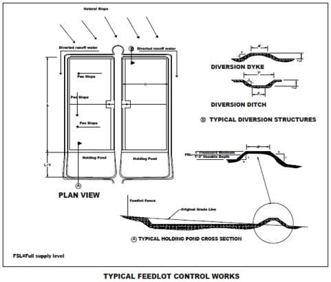
Fig drawing of typical feedlot control works

The construction technique used for holding ponds will determine the effectiveness of the soil-seal formed.

The basic construction standard for holding ponds is to disc the final surface on the bottom and sides to a six-inch depth and then compact with a sheeps-foot packer.
  • Place soil for dikes in six-inch lifts and compact with a sheeps-foot packer.
  • Do not use topsoil for the construction of dikes.

Soil performance is greatly improved by using the proper construction techniques. A detailed site investigation will allow an engineer to recommend construction techniques that will ensure groundwater safety.

Geologically sensitive sites may lead to installation of sampling wells to monitor seepage from holding ponds and to determine the effect on groundwater quality. A regular monitoring program will allow corrective action to be taken when necessary. It is preferable to locate holding ponds on sites where monitoring is unnecessary.

Top

6. Maintenance and safety

Cattle should not have access to holding ponds. If the holding pond is located where cattle have access, lower side slopes should be used so hoof action does not reduce the holding pond's effective volume. Deep holding ponds should be fenced as a safety precaution to prevent access by children and livestock.

Apply effluent from holding ponds on the land according to normally accepted agricultural practice. Liquid manure handling equipment can be used for this operation, although solids removal may be required from time-to-time.

Holding ponds within public view should have the vegetation mowed and be maintained in a neat manner. An unsightly holding pond will reflect on the overall perception of the livestock operation. Trees can be planted to screen the site and to improve appearance. Trees should be set back to allow equipment access to the pond and to reduce the effect of snow buildup on holding pond volume in the spring.

Top

7. Other options

Contained sloughs

Sloughs contained entirely on your property may serve as holding ponds, provided they have sufficient capacity and the site investigation confirms soils with sealing properties and sufficient thickness to minimize infiltration.

To determine if the slough has sufficient capacity to hold current runoff plus the additional feedlot runoff, a perimeter topographical survey and an estimate of potential volume of the slough is required. Test holes around the edge of the slough are required to ensure proper soil types are present and to ensure that the slough is not a groundwater recharge site.

Not entirely contained sloughs

Sloughs not entirely contained on the operator's property can be used as holding ponds with the written permission of adjacent landowners. The testing and surveying requirements for a self-contained slough would apply. The agreement to allow runoff to be contained on another party's land should address long-term potential changes in ownership or land use. A caveat may be an option.

Vegetative filter strips may have potential to assist in the removal of nutrients from surface runoff. Vegetative filter strips are not a stand-alone practice, but are used in conjunction with other techniques for preventing pollution of surface water. Some of the factors considered in designing of filter strips are land slope, soil type, vegetation present, climate and the nature of any water receptors.

We need your feedback to improve saskatchewan.ca. Help us improve